
Projects

Bakırköy Taksiarhis Greek Orthodox Church - Orthophoto Production
Laser Scanning and Orthophoto Production with Leica RTC360

Tüpraş Pipeline Reverse Engineering Project using Laser Scanning
3D Surveying Service with Terrestrial Laser Scanners

MSB - Measurement of Mechanical Lines with Terrestrial Scanning Systems
3D Laser Scanning Measurement of Mechanical Equipment with Leica RTC360

OTS Project – 3D Surveying and Revit Model Delivery with Terrestrial Laser Scanners
Kemer Country Villas 3D Survey and Revit Modeling Service

Mobile Lidar Measurement with UAV in Bahçeköy
Map Production Using UAVs in Bahçeköy, Sarıyer

Namet Gümüşova OSB Integrated Facility Construction Project
Project Consulting and Advisory Services

Izmir Tüpraş – Topographic Measurement with Laser Scanning Systems
Industrial Plant Plan with Leica RTC360

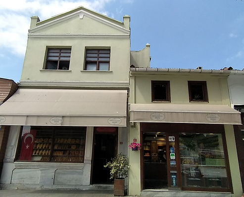
MacroCenter – Yeniköy 2D Architectural Survey Project
Fast and Accurate Architectural Surveys with Scan2CAD

Borusan Gemlik – Industrial Machine Measurements
Creating 2D Machine Projects Through Reverse Engineering

Stockyard Measurement with MAIS UAV Systems
High-Precision Ground Map Measurements with Drones

Adoçim Cement - MARMARA CLINKER
STOCKHOLE ROOF MEASUREMENT
3D Geometry Analysis with Laser Scanner Systems

Assan Aluminum – Machine Room Scan to BIM Project
3D Scanning and BIM Modeling of Tuzla Cold Rolling Mill-2 Filter Room

Dudullu Organized Industrial Zone – Industrial Facility 3D Modeling Project
Seamless "Digital Twin" solutions for your industrial facilities without halting production.

Sarıyer 108 Island 1 Parcel Restoration Measurement
The foundation of accurate restoration: millimeter-accurate surveying and 3D measurement.

Balat 1910 Block 74 Parcel Restoration Measurement
We are transferring historical texture to digital format with millimeter precision.

2D Survey Measurement for Pet Shop at Bursa Nilpark Shopping Mall
Precise Surveying and Ceiling Plan Work for Interior Architectural Design.

Malatya Yeşilyurt Family Health Center Strengthening Project
Architectural Survey and Current Situation Assessment

Tank Verticality and Ovality Measurement at Shell Derince Facilities
Geometric Analysis and Deformation Reporting

Bodrum Mandarin Oriental - Gigi Beach 2D Survey
Precise Laser Scanning and Surveying with Leica RTC360

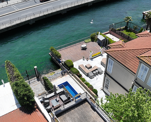
Sarıyer Waterfront Facade 2D Survey Project
Leica RTC360 Technology Speeds Up Facade Surveying


3D Survey of Cyprus Lord's Palace - Lagoon Beach Hotel
Different Locations, One Digital Reality

Bakırköy Mental and Neurological Diseases Hospital - Facade Measurements
Laser Scanning and As-Built Project Design

3D Modeling of Enersa Industrial Machinery
Laser Scanning and Reverse Engineering of Industrial Equipment

Acıbadem City Hospital Scan to BIM Project
Acıbadem City Hospital – Current Situation Documentation Study with Laser Scanning

FBÜ - Laser Scanning Solutions
Fenerbahçe University – Laser Scanning and Documentation Study of Electrical Lines

TANAP Project – Laser Scanning and Technical Inspection Services
Reverse Engineering and Inspection Processes with Laser Scanning Data
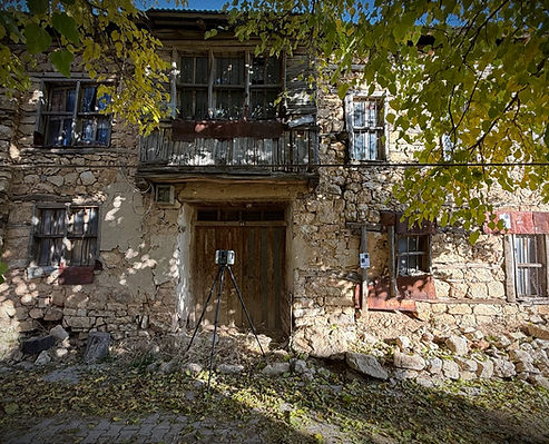
Arapgir Historic Houses 3D Restoration Project with Laser Scanning
Design of Historical Buildings Damaged by the Disaster by the Ministry of Culture and Tourism Following the February 2023 Earthquakes

AYGM Halkalı-Ispartakule Line GNSS Network Balancing
Geodetic infrastructure strengthened on the Halkalı–Ispartakule line.

Current Map Survey of Şanlıurfa Light Rail Systems
Şanlıurfa Light Rail Systems – Current Map Survey


Lajthiza Roof Project Laser Scanning and 3D Surveying
The Lajthiza Roof is Reborn in Albania
Akmanoğlu Furnace Restoration Measurement
Precise Documentation and Restoration Base for Historical Buildings with Laser Scanning

Kurtköy Storage Area Planed Dimension Measurement
Integrated Measurement and Mapping with Total Station, GNSS and Drone Technologies

Borusan Halkalı Factory 2D Mechanical Drawing
Precise 2D Plans for Factory Measurement and Pipe Machinery with Laser Scanning

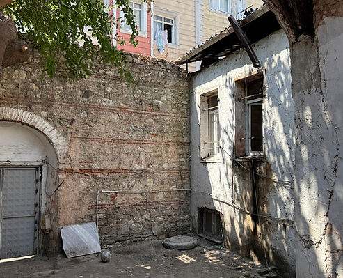
Sultanahmet Kupacılar Street Restoration Measurement
Precise Measurement and Documentation of Historical Texture with Laser Scanning
Kumkapı Historical Building Restoration Measurement
Precise Measurement and Documentation for Historical Buildings with Laser Scanning

Nişantaşı İmren Apartment Restoration Measurement
Precise Measurement with Laser Scanning, Reliable Bases for Restoration Projects

Beylikdüzü Twin Villas 3D Modeling Project
High Precision Measurement with Laser Scanning, Closest to Life 3D Model

Kempinski Residences Balmumcu Roof Survey
Millimetric Accuracy Measurement with Total Station, Detailed 3D Modeling
Remzi Bey Mansion Restoration Project
3D Laser Scanning and Orthophoto Work at Remzi Bey Yalı

Survey of Haan Living with Laser Scanner Systems
Precise 3D Laser Scanning and Orthophoto Work

Daru Sultan Hotel 3D Survey Project
The Soul of a Building is Documented with Light and Points: The Digital Survey of Daru Sultan

Survey Project of Beyoğlu with Laser Scanner Systems
Millimetric Survey Work with Laser Scanning in Beyoğlu

Excavation and Fill Calculations for Başakşehir Highway Route
High-Precision Data Collection with Photogrammetric Methods

Deflection Analysis Work of Prestressed Precast Beams
Deflection Analysis Work of Prestressed Precast Beams for the North Marmara Highway Nakkaş – Başakşehir Section Project


Survey Mapping in Fatsa District, Ordu Province
Survey Mapping for Infrastructure and Construction Projects in Fatsa District, Ordu Province

Arapgir Historic Houses: Surveying and Restoration Project
Ministry of Culture and Tourism-Funded Project for the Design of Historic Structures Damaged in the February 2023 Earthquakes